Part 107 Airspace Cheat Sheet (2026)
Updated 2026-10-17. Independent guide, not affiliated with the FAA.
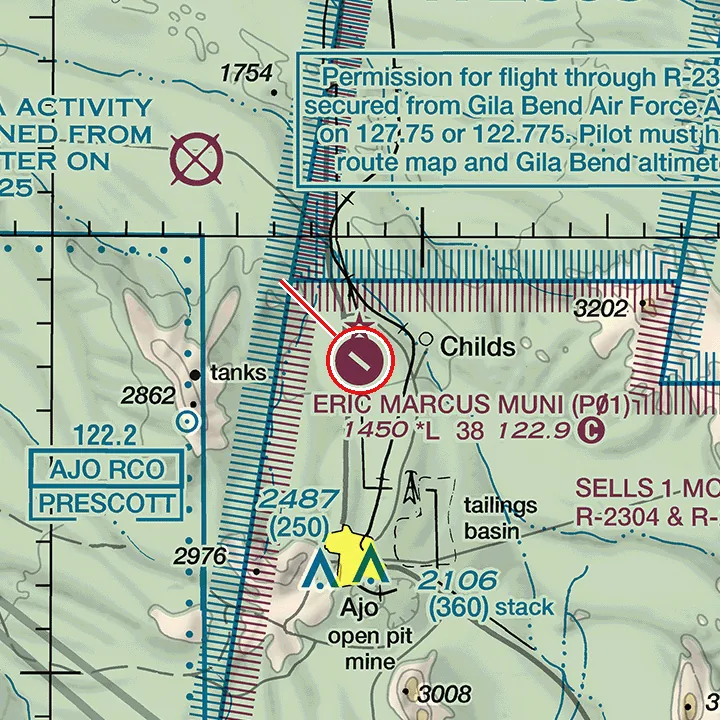
Short answer: On a sectional chart, Class B is a solid blue line, Class C is solid magenta, Class D is dashed blue, and a Class E surface area (E2) is dashed magenta. A small drone needs ATC authorization (LAANC or FAADroneZone) whenever it is actually inside one of them. Outer Class B and C shelves start well above the ground, so check the floor/ceiling label against your altitude before deciding. Below a magenta or blue shaded edge, Class G usually runs up to 700 or 1,200 ft AGL, and no authorization is needed there under 400 ft.
Try 10 chart questions free
Excerpts from current FAA sectionals, worked explanations, score by topic. About 5 minutes, no signup.
Take the free 10-question chart diagnosticHow does each airspace class look on a sectional chart?
| Airspace | Chart symbol | Usual vertical limits | Drone needs ATC authorization? |
|---|---|---|---|
| Class B | Solid blue lines, shelves labeled ceiling/floor in hundreds of feet MSL (for example 100/SFC) | Surface to about 10,000 ft MSL near the airport; outer shelves have higher floors (for example 100/40 = 4,000 to 10,000 ft MSL), layered like an upside-down wedding cake | Yes when you are inside it (14 CFR 107.41). Under a shelf whose floor is above your altitude, you are not in Class B |
| Class C | Solid magenta lines, labels like 48/SFC | Inner core from the surface to about 4,000 ft above the airport; the outer shelf usually starts around 1,200 ft above the airport (labels like 40/12), charted in MSL | Yes when you are inside it. Below the outer shelf floor you are not in Class C |
| Class D | Dashed blue line, ceiling in a box such as [32] = 3,200 ft MSL; a minus sign [-32] means up to but not including | Surface to about 2,500 ft above the airport | Yes, while it is in effect (check part-time towers) |
| Class E surface area (E2) | Dashed magenta line around an airport | Starts at the surface | Yes |
| Class E extension (E4) | Dashed magenta area sticking out from a Class D or E2 area, usually along an approach path | Starts at the surface | No. E4 needs no ATC authorization for a drone. To tell E4 from E2, check the FAA UAS Facility Map or your LAANC app |
| Class E from 700 ft AGL | Magenta shaded band (vignette); the fuzzy side faces the area where E starts at 700 ft | Floor 700 ft AGL | No, if you stay under 400 ft AGL in the Class G below |
| Class E from 1,200 ft AGL | Blue shaded band (vignette): Class E begins at 1,200 ft AGL on the shaded side. Across most of the country it is also the default floor where no other shading appears. Floors other than 700 or 1,200 ft are labeled with a number | Floor 1,200 ft AGL | No, under 400 ft AGL |
| Class G | No line; it is what is left below the Class E floor | Surface up to 700 or 1,200 ft AGL in most places | No |
Source: FAA Aeronautical Chart User's Guide (faa.gov) and 14 CFR 107.41 (ecfr.gov).
Which special use areas matter for a drone?
| Area | Chart symbol | What it means for a Part 107 flight |
|---|---|---|
| Prohibited (P-) | Blue hatched border | Do not fly without permission from the using or controlling agency (14 CFR 107.45) |
| Restricted (R-) | Blue hatched border | Do not fly when active without permission from the controlling agency; times are in the chart margin |
| Military Operations Area (MOA) | Magenta hatched border | The MOA itself needs no authorization, but the airspace underneath still applies (Class B, C, D or a Class E surface area still needs it), and fast military traffic is possible |
| Military Training Route (IR/VR) | Gray line with number | Low, fast military jets; watch and listen |
| Temporary Flight Restriction (TFR) | Not on the chart | Check NOTAMs and the FAA TFR list before every flight |
What Part 107 limits should be on the same page?
- Maximum altitude: 400 ft AGL, or within 400 ft of a structure and no higher than 400 ft above its top (14 CFR 107.51).
- Maximum groundspeed: 87 knots (100 mph).
- Minimum visibility: 3 statute miles from the control station.
- Cloud clearance: 500 ft below, 2,000 ft horizontally.
What do the numbers in an airport data block mean?
Example: 285 L 72 122.95
- 285: airport elevation in feet MSL
- L: runway lighting
- 72: longest runway, 7,200 ft
- 122.95: UNICOM frequency
- A circled C marks the CTAF (blue at towered airports, magenta at non-towered ones, like the rest of the airport data). A star next to the tower frequency means the tower is part-time.
What about obstacles?
Obstacle elevations are printed in bold as feet MSL, with height above ground in parentheses: 1549 (1124) means the top is 1,549 ft MSL and the structure stands 1,124 ft AGL.
Worked example
A question shows an airport inside a dashed blue line with [-25] in a box, a star next to the tower frequency, and asks whether you need authorization at 200 ft AGL on a Sunday evening.
- Dashed blue = Class D, ceiling up to but not including 2,500 ft MSL.
- The star = part-time tower. When the tower closes, the airspace changes (often to Class E surface or Class G). The Chart Supplement lists the hours.
- So the answer depends on the tower's hours: authorization is required while the Class D is in effect, and the test expects you to know the star means "check the hours".
Why does this matter more after October 26, 2026?
From October 26, 2026 the Part 107 (UAG) test includes image questions taken from recent sectional charts that are not in the testing supplement, so you cannot memorize the supplement figures (FAA Airman Testing Community Advisory, September 2026 Special Edition: faa.gov). You need to read symbols cold, which is exactly what this table is for.
Practice it on real charts
Reading a table is not the same as reading a chart you have never seen. Take the free 10-question chart diagnostic (about 5 minutes, no signup) on excerpts from current FAA sectionals.
FAQ
- Do I need authorization in a MOA?
- Not for the MOA itself. But the MOA does not replace the airspace class underneath: if that is Class B, C, D or a Class E surface area, you still need ATC authorization. Military aircraft may be operating, so stay alert.
- Is Class E at 700 ft AGL controlled airspace for my drone?
- The Class E itself starts at 700 ft AGL. Below it is Class G, so a drone flying at or under 400 ft AGL there needs no authorization.
- What does a minus sign in a Class D ceiling box mean?
- It means the Class D goes up to, but does not include, that altitude in hundreds of feet MSL. [-25] means up to 2,499 ft MSL, with the airspace above belonging to another class (often Class C or B).
- Can I bring this cheat sheet into the test?
- No. Study aids are not allowed in the testing center. The center provides the official testing supplement.
- Where do I get current sectionals?
- Free from the FAA: https://www.faa.gov/air_traffic/flight_info/aeronav/digital_products/vfr/ . Charts are reissued every 56 days; the next edition is effective October 29, 2026.
Full access
$24 one-time. No subscription.
The FAA test costs about $175 at the testing center, and a fail means a 14-day wait to retest.
- 178 chart questions on excerpts from current FAA sectionals, each with a worked explanation
- 305 general Part 107 questions mapped to Remote Pilot ACS codes
- Timed 60-question mock exams in the FAA test format (2 hours, 70% to pass)
- Read the current chart mode: unseen chart excerpts, timed
- Spaced repetition review that remembers what you miss
- No account, no subscription, works on your phone
- No account
- Works on your phone
- Instant access
SectionalDrill is independent and not affiliated with the FAA, the U.S. government or any government agency.