Airport chart walkthroughs / SEE
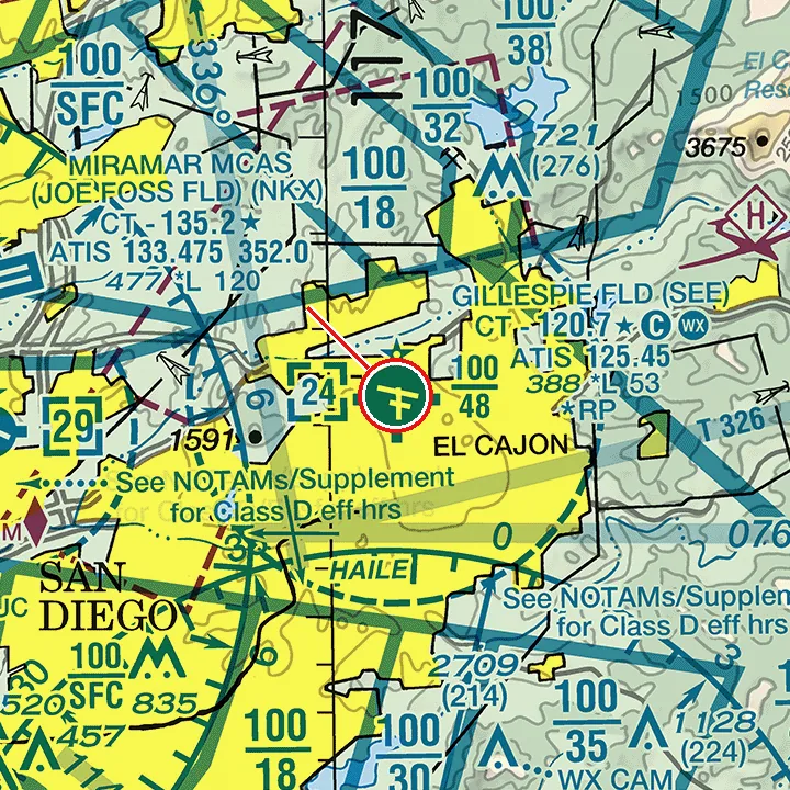
Gillespie Field (SEE) on the sectional chart
FAA Los Angeles sectional, Sep 3, 2026 edition. Study use only, not for navigation.
How to read the Class D airspace, part-time tower and CTAF at Gillespie Field on the FAA Los Angeles sectional: the kind of chart reading the Part 107 test asks for. Two practice questions with worked answers below.
What the chart and FAA data show
| Item | Value |
|---|---|
| Sectional chart | Los Angeles, Sep 3, 2026 edition |
| Airspace at the field | Class D (dashed blue line), part-time tower |
| Class D vertical limits | From the surface up to and including 2,400 ft MSL |
| Field elevation (FAA NASR) | 387.5 ft MSL |
| Top of the Class D above the field | about 2,012 ft |
| Tower hours (FAA NASR) | 0700-2100 local |
| CTAF when the tower is closed | 120.7 |
How to read it
Find the dashed blue circle around SEE: that is Class D airspace. The boxed number inside it, [24], is the ceiling in hundreds of feet MSL, so this Class D goes up to 2,400 ft MSL. Subtract the field elevation (387.5 ft) to get the height above the airport: about 2,012 ft. Chart altitudes for airspace are MSL unless marked AGL.
In the airport data block, the star after the tower frequency (CT - 120.7) means the tower is part-time, and the magenta C means that frequency is also the CTAF when the tower is closed. When the tower closes, the airspace usually reverts to Class E or Class G; the Chart Supplement has the details.
For a drone: flying a small UA in Class D airspace needs ATC authorization first (LAANC or FAA DroneZone; 14 CFR 107.41).
Practice: 2 questions on this chart
Practice question 1 of 2
Refer to the marked airport. What are the vertical limits of the Class D airspace at GILLESPIE FLD (SEE)?
- A. From the surface up to and including 2,400 ft MSL
- B. From the surface up to and including 2,012 ft MSL
- C. From the surface up to and including 2,400 ft AGL
Show the answer
Answer: A. From the surface up to and including 2,400 ft MSL
Inside the dashed blue Class D circle you'll find a number in a box: [24]. It gives the ceiling in hundreds of feet MSL, so this Class D goes from the surface to 2,400 ft MSL. Field elevation is 388 ft MSL, so the Class D extends about 2,012 ft above the airport. Chart altitudes for airspace are MSL unless marked AGL.
Question ID: c-4bdeaa94bb | ACS UA.II.A.K1c
Practice question 2 of 2
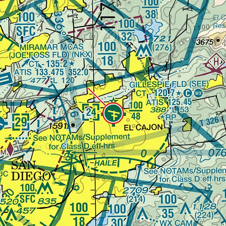
Refer to the marked airport. If the control tower at GILLESPIE FLD (SEE) is not in operation, which frequency should be used as the CTAF to monitor airport traffic?
- A. 120.7
- B. 121.7
- C. 125.45
Show the answer
Answer: A. 120.7
The airport data block shows the tower frequency after CT: CT - 120.7, followed by a star and a magenta C. The star means the tower is part-time (hours are listed in the Chart Supplement: 0700-2100 local). The magenta C next to it means the tower frequency becomes the CTAF when the tower is closed, so the answer is 120.7. The other choices are frequencies printed nearby for other services (ATIS, ground, UNICOM). When the tower closes, Class D airspace usually reverts to Class E or Class G; check the Chart Supplement.
Question ID: c-6dedca57b0 | ACS UA.V.A.K1, UA.V.A.K2, UA.V.B.K2
Try 10 chart questions free
Excerpts from current FAA sectionals, worked explanations, score by topic. About 5 minutes, no signup.
Take the free 10-question chart diagnosticRelated guides: How to read a sectional chart, CTAF and part-time towers, Airspace classes for drone pilots.
Full access
$24 one-time. No subscription.
The FAA test costs about $175 at the testing center, and a fail means a 14-day wait to retest.
- 178 chart questions on excerpts from current FAA sectionals, each with a worked explanation
- 305 general Part 107 questions mapped to Remote Pilot ACS codes
- Timed 60-question mock exams in the FAA test format (2 hours, 70% to pass)
- Read the current chart mode: unseen chart excerpts, timed
- Spaced repetition review that remembers what you miss
- No account, no subscription, works on your phone
- No account
- Works on your phone
- Instant access
SectionalDrill is independent and not affiliated with the FAA, the U.S. government or any government agency.